
Physical Feature: Ancient seafloors
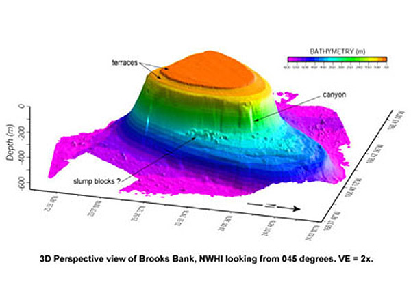
Bathymetric image of Brooks Bank. Photo Credit: NOAA Ship Hiʻialakai
The high resolution seafloor topography data shown in this image reveals the flat-topped nature of many of the seamounts and atolls in the Northwestern Hawaiian Islands (NWHI). These seamounts were formed by erosion when their tops were near sea level. Brooks Bank, pictured here, has two distinct terraces at -75 and -125 m illustrating the affects of at least two distinct sea level stands on the Bank. There is over 500 m of relief between the top of Brooks Bank and the surrounding seafloor and large submarine canyons characterize the steep slopes below the incised edges of the Bank top. Blocks of material at the base of the slopes are probably slumps or landslide deposits similar to material mapped around the Main Hawaiian Islands, believed to be deposited during catastrophic landslide events. Information gained from images like these give insight into the evolution of the Hawaiian Islands, and provide base layers for benthic habitat mapping.
Click Here for more information (you will be directed to a non-NOAA website).
Co Trustees |
World Heritage |
Big Ocean |
Contact Us Link Disclaimer User Survey Privacy Policy |
Revised December 5, 2022 by PMNM Webmaster Web site owner: National Ocean Service Office of National Marine Sanctuaries National Oceanic and Atmospheric Administration Main Office: NOAA/Daniel K. Inouye Regional Center NOS/ONMS/PMNM, 1845 Wasp Blvd, Building 176 Honolulu, HI 96818 | Phone: 808-725-5800 | Fax: 808-455-3093 |