Hawaiian Voyaging and Wayfinding
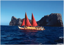 Today, Papahānaumokuākea’s cultural landscape, dominated by the ocean, plays a critical role in two major living traditions of Native Hawaiians: Hawaiian voyaging and wayfinding. The voyaging route between Kaua‘i (in the main Hawaiian Islands) and Nihoa and Mokumanamana is used today as the best training ground for apprentices of Hawaiian wayfinding, non-instrument navigation, before undertaking a long, open ocean voyage beyond the archipelago. At Papahānaumokuākea, an array of attributes unique in the archipelago makes the area “the ideal training platform” for novice Hawaiian wayfinders (Nainoa Thompson 4 October 2008, personal communication). Apprentice navigators are challenged to sail to Nihoa from Lehua, a small, crescent shaped island near Kaua‘i and Ni‘ihau. Oral histories document that this navigational test was used in generations past; it is an ideal route for a novice navigator to prove new skills in reading the celestial and ocean environment (Maly 2003). The navigator must find an island that cannot be seen on the horizon, but is still within a relatively short sail from the safety and provisions of a larger island. Oral tradition tells that in fair weather, canoes would sail first from Kaua‘i to Lehua, which is known as a navigational “pointer” to Nihoa. On Nihoa, there is no artificial lighting to aid the apprentice navigator, and the island’s small physical size (0.68 square kilometers) and low-lying nature (the highest point measures 275 meters) require astute observations of the sun, stars, swells, seabirds and the Hawaiian wayfinder’s other signposts of navigation. Today, novice Hawaiian wayfinders are considered qualified to attempt to navigate a canoe on long-distance, trans-Pacific sails after they have successfully guided a voyage from Kauai to Nihoa. Once the voyages to Nihoa, and then Mokumanamana, have been made, the islands themselves contain archaeological sites that continue to be used to educate apprentice navigators and allow for direct communication with the elements and the gods who are personified in those elements (Pualani Kanahele 2 July 2008, personal communication). Even apart from apprentice sails, Papahānaumokuākea is a major destination for traditional voyaging. Traditional double-hulled Hawaiian voyaging canoes have traveled throughout Papahānaumokuākea in recent years. In 2004, Hōkūle‘a sailed from the main Hawaiian Islands to Kure Atoll, the farthest edge of the former Hawaiian Kingdom, and back. Moreover, the ‘Ohana Wa‘a (family of canoes) serve as the traditional vehicles that deliver cultural practitioners to Nihoa and Mokumanamana for religious ceremonies. In two separate voyages in 2003 and 2005, Hōkūle‘a and Hōkūalaka‘i brought the cultural group Nā Kupu‘eu Paemoku to Nihoa and Mokumanamana for ceremonial purposes. Oral traditions reveal this seascape’s place in Hawai‘i’s legendary voyaging traditions. Küpuna (elders) from Ni‘ihau and Kaua‘i Islands (which are closest to Papahānaumokuākea and the people of which have traditionally had the most access to and relationship with the islands to the northwest) have shared knowledge passed down through generations about a voyaging “route” to Tahiti (Maly 2003). Although trans-Pacific voyaging is thought to have ceased in the 15th century (Kirch and Kahn 2007), some Ni‘ihau traditions state that Nihoa and/or Mokumanamana served as an embarkation and debarkation point for these voyages (Maly 2003). Traditions from Hawai‘i Island support this, suggesting that in recent centuries, Ni‘ihau and Kaua‘i were particularly known for deep-sea voyaging wisdom (ibid.). The late kūpuna Eddie Ka‘anā‘anā spoke of Native Hawaiians voyaging from Hawai‘i Island to join family members in Ni‘ihau to sail from there to Papahānaumokuākea. His family told him that they did this to fish and to holo moana—to train to gain navigational knowledge (ibid.).
Co Trustees |
World Heritage |
Contact Us Link Disclaimer User Survey Privacy Policy |
Revised December 5, 2022 by PMNM Webmaster Web site owner: National Ocean Service Office of National Marine Sanctuaries National Oceanic and Atmospheric Administration Main Office: NOAA/Daniel K. Inouye Regional Center NOS/ONMS/PMNM, 1845 Wasp Blvd, Building 176 Honolulu, HI 96818 | Phone: 808-725-5800 | Fax: 808-455-3093 |