
Papahānaumokuākea Intertidal Monitoring Cruise Survey Team Reflections October 1 – 14, 2011
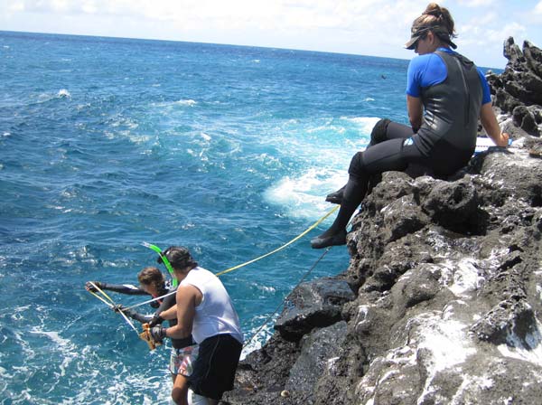
Researchers Emily Fielding, Brian Villiarimo and Ilysa Iglesias measure 'opihi habitat on the rocky shoreline within Papahānaumokuākea. Credit: Hoku Johnson
From October 1 – 14, 2011, Papahānaumokuākea Marine National Monument completed the third consecutive year of research and monitoring activities along the shallow, wave-swept rocky shorelines (also known as the "intertidal zone") of Nihoa, Mokumanamana and French Frigate Shoals in the Northwestern Hawaiian Islands. This year was the first to apply and integrate both western research and traditional Hawaiian science methodologies while undertaking intertidal monitoring activities. The 2011 intertidal monitoring team consisted of nine individuals with diverse backgrounds, all of whom teamed up to collect data along the rocky shorelines of the Northwestern Hawaiian Islands.
Following are the Survey Team Reflections:
- Brian Villiarimo – Nā Mamo O Mūʻolea
- Patrick Springer – Protect Papahānaumokuākea ʻOhana
- Christopher Holz – Kalapana Fishing Council
- Chris Bird – Hawaiʻi Institute of Marine Biology
- Emily Fielding – The Nature Conservancy (TNC)
- Ilysa Iglesias – Hawaiʻi Institute of Marine Biology
- Levi Lewis – Scripps Institution of Oceanography
- Shauna Kehaunani Springer – Protect Papahānaumokuākea ʻOhana
- Hoku Johnson – Papahānaumokuākea Marine National Monument
Click Here for more information on the 2011 Intertidal Monitoring Cruise.
Click Here to view the Press Release (1.9mb pdf).