
Western and Hawaiian Science Combine to Provide Management Baseline for ʻOpihi
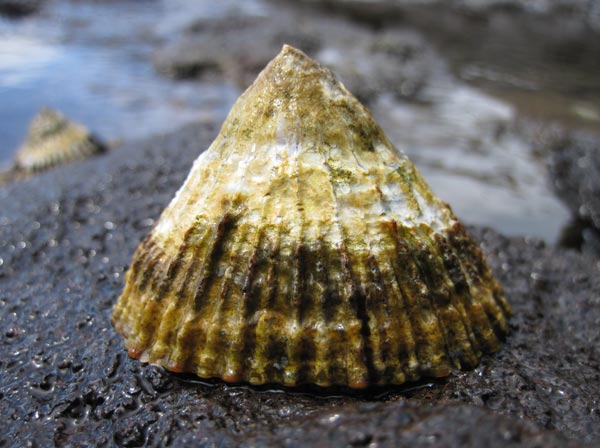
A blackfoot ʻopihi, or ʻopihi makaiaūli on the rocks in the Northwestern Hawaiian Islands. Credit: Shauna Kehaunani Springer
From October 1 – 14, 2011, Papahānaumokuākea Marine National Monument's intertidal monitoring expedition completed the third consecutive year of research and monitoring activities along shallow, wave-swept, rocky shorelines of Nihoa, Mokumanamana, French Frigate Shoals and Gardner Pinnacles in the Northwestern Hawaiian Islands (NWHI). Focused on ʻopihi and other species that inhabit the rocky shorelines, this interdisciplinary cruise purposely integrated western research activities with Native Hawaiian cultural knowledge and approaches – a central aim of the Monument's Management Plan.
"Although coral reef surveys have been conducted for years in the NWHI," said Hoku Johnson, NOAA's coordinator of the expedition, "the intertidal area from the 'splash zone' to just beneath the breaking waves is in some ways a new frontier, one not previously characterized by scientists with scuba gear. However, it's an area that was of great traditional importance to Native Hawaiians."
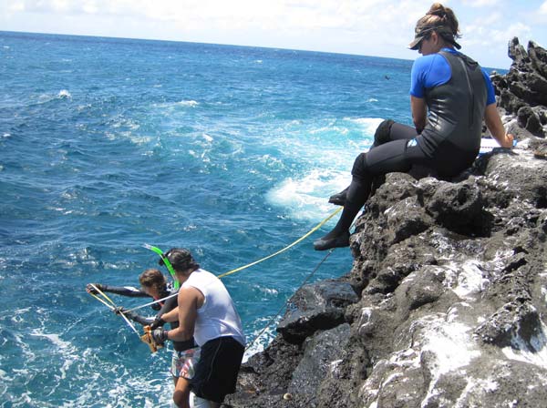
Researchers Emily Fielding, Brian Villiarimo and Ilysa Iglesias measure 'opihi habitat on the rocky shoreline within Papahānaumokuākea. Credit: Hoku Johnson
"Intertidal shorelines are where Native Hawaiian women went to gather while the men fished," said Shauna Kehaunani Springer, a cultural researcher and monitoring team member from Hawai'i Island. "'Opihi and hā'uke'uke (helmet urchin) were eaten; their shells were used as tools for everything from scraping kalo (taro) and niu (coconut) to imprinting kapa cloth. While working in Papahānaumokuākea, it was our responsibility to make sure we honored the areas we worked in by offering chants and small gifts of water and salt prior to conducting any of our activities," Springer said.
The monitoring team consisted of biologists from the Hawai'i Institute of Marine Biology (HIMB) and the Scripps Institute of Oceanography in California, conservation organizations such as The Nature Conservancy, and community members from Hana, Maui and Kalapana, Hawai'i Island. "Up until three years ago, there really wasn't any data collected in the Northwestern Hawaiian Islands on rocky shoreline areas," said Dr. Chris Bird, a scientist with HIMB. "Compared to the main Hawaiian Islands, the rocky shorelines within the Monument are pristine and host many species of invertebrates, fish, and seaweeds, but it's a challenging place to work. You have to be part mountain goat, and part 'a'ama crab."
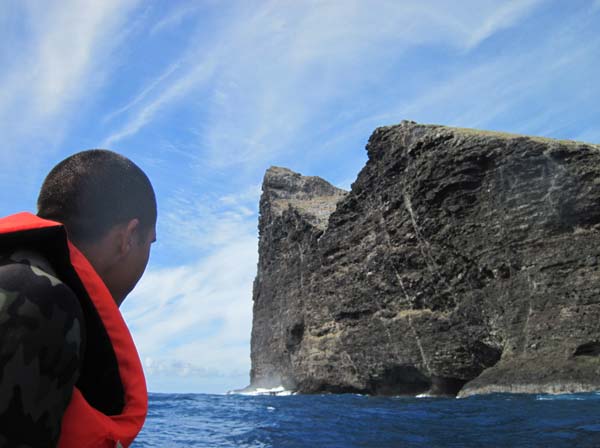
Researcher Patrick Springer evaluates the water conditions below the sheer cliffs of Nihoa Island. Credit: Shauna Kehaunani Springer
"We added a new component to this trip," noted Springer. "Everyone on the team recorded weather observations and species interactions on a data sheet, which, upon further analysis, may provide additional insight into the state of the resources within the intertidal zones in the NWHI from a Native Hawaiian perspective." The cultural data sheets have already been implemented for 'opihi monitoring projects within the main Hawaiian Islands. "The (data sheets) have proved time again that our kūpuna were true Hawaiian scientists, and their mo'olelo (stories), oli (chants), and mele (songs) were the first 'data' recorded," Springer said. "Our ancestors really knew how to live within their means and treated their surrounding environment with reverence and respect."
"It's amazing to count 'opihi, crabs, limu and fish in a place that is so abundant like the Northwestern Hawaiian Islands," said Brian Villiarimo, a member of the monitoring team, and community advocate from Hana, Maui. "You can really see the potential of what the eight main Hawaiian Islands could look like, if we all aimed to harvest responsibly."
"This trip made me hopeful that we if we protect and limit our take in more areas in the main Hawaiian Islands, there will be abundance for future generations, which will allow us to continue to teach our children and our grandchildren to keep with the practices of our ancestors," Springer summarized.
Click Here to view the Intertidal Monitoring Cruise Survey Team Reflections.
Click Here to view the Press Release (1.9mb pdf).

Researchers Emily Fielding and Ilysa Iglesias record intertidal species along a transect line on the rocky shoreline in the Northwestern Hawaiian Islands.
Credit: Shauna Kehaunani Springer

Researchers monitor the rocky shoreline - habitat for ʻopihi, limu, aʻama crabs and numerous invertebrate species.
Credit: Hoku Johnson