
IMO Particularly Sensitive Sea Area
For Vessel Reporting Information, Click Here.
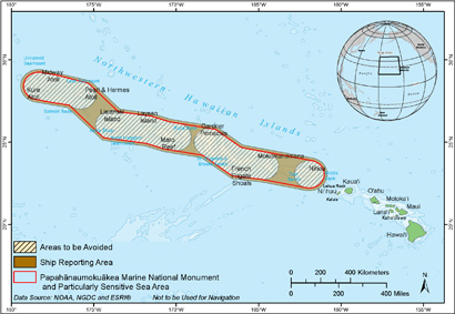
Papahānaumokuākea Marine National Monument and Particularly Sensitive Sea Area boundaries map. For more detailed boundary information, visit www.pmnmims.org/data/index.aspx
Papahānaumokuākea Marine National Monument (Monument) was designated a "Particularly Sensitive Sea Area" (PSSA) in 2008 by the International Maritime Organization, to protect marine resources of ecological or cultural significance from damage by ships while helping keep mariners safe.
"NOAA welcomes this additional layer of protection and international recognition for the Papahānaumokuākea Marine National Monument," said retired Navy Vice Adm. Conrad C. Lautenbacher, Ph.D., former Under Secretary of Commerce for Oceans and Atmosphere and NOAA Administrator. "This designation will alert international mariners to exercise extreme caution when navigating through the Monument."
The Particularly Sensitive Sea Area designation establishes four special zones known as "Areas to be Avoided" (ATBAs) on international nautical charts to direct ships away from coral reefs, shipwrecks and other ecologically or culturally sensitive areas that may pose a navigation hazard (73 Federal Register 233 (3 December 2008), pp. 73592 - 73605). Additionally, an integral part of this management strategy has been ship monitoring. Vessels planning to pass through the Monument PSSA on their way to or from a U.S. port or place must notify managers entering and exiting according to the Monument's ship reporting requirements.
While the Northwestern Hawaiian Islands are one of the most remote places on earth, international shipping traffic is still present around its waters. North of the Monument lies the great circle routes to and from ports on the west coast of North America and East Asia. Other trans-Pacific ships traveling from ports in Hawaii transit to the south of Papahānaumokuākea Marine National Monument. To learn more about vessel traffic patterns in the monument see the following link:
An assessment of traffic patterns in the Northwestern Hawaiian Islands between 1994 and 2004 (PDF 266KB)
Franklin, E.C. 2008. Marine Pollution Bulletin 56: 150-153.