Stay Connected

About US
Papahānaumokuākea Information Management System (PIMS)
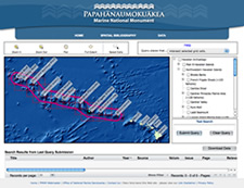 PIMS is a web portal that provides managers, researchers and the public easily accessible information about the natural, cultural, and historic resources of the Northwestern Hawaiian Islands. http://www.pmnmims.org/
The goal of PIMS is to “Consolidate and make accessible relevant information to meet the educational, management and research needs for the Papahānaumokuākea Marine National Monument” (Monument Management Plan, 2008).
This system is evolving over time as user needs are identified. Tools currently under development include:
- Online permitting system
- Species information search and mapping
- Digital media
- Other management and mapping tools
Spatial Bibliography
The Spatial Bibliography allows users to search a catalog of over 2,300 publications related to research done in the Northwestern Hawaiian Islands, including journal articles, books and agency reports dating as far back as 1834. Bibliographic entries are indexed by species, author, publication and geographic location and may be searched textually, graphically via an interactive map, or by using a combination of methods.
http://www.pmnmims.org/Default.aspx
Spatial and Mapping Products
Data that provide both maps and data for mapping tools such as ArcGIS and Google Maps that define the boundaries of geoloagic, habitat and political features of the Monument.
http://www.pmnmims.org/data/index.aspx
Co Trustees |
World Heritage |
Big Ocean |
Contact Us Link Disclaimer User Survey Privacy Policy |
PMNM Webmaster Web site owner: National Ocean Service Office of National Marine Sanctuaries National Oceanic and Atmospheric Administration Main Office: NOAA/Daniel K. Inouye Regional Center NOS/ONMS/PMNM, 1845 Wasp Blvd, Building 176 Honolulu, HI 96818 | Phone: 808-725-5800 | Fax: 808-455-3093 |