President announces expansion of Papahānaumokuākea
On Friday, August 26, 2016, President Obama signed a proclamation expanding the Papahānaumokuākea Marine National Monument. Previously the largest contiguous fully-protected conservation area in the United States at 139,797 square miles (362,073 km2), the expanded boundaries make it once again the biggest protected area on the planet at 582,578 square miles (1,508,870 km2), nearly the size of the Gulf of Mexico.
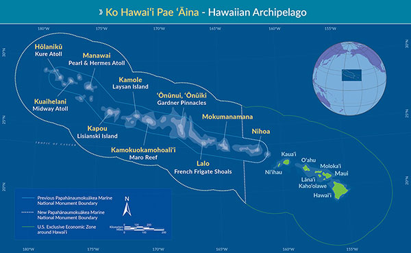 Map of Hawaiʻi highlighting Papahānaumokuākea's new boundaries. |
Papahānaumokuākea is globally recognized for its biological and cultural significance, being the only mixed UNESCO World Heritage site in the United States and only one of 35 mixed sites in the world. Its long list of protections includes designation as a Particularly Sensitive Sea Area by the International Maritime Organization. See full list of protections here.
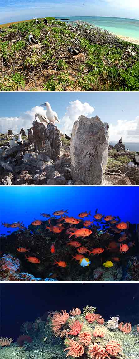 Papahānaumokuākea is home to millions of seabirds, a number of important Native Hawaiian cultural sites, a variety of endangered and unique species, and high-density deep-sea biological communities. Photo credits from top to bottom: James Watt/Seapics; Kaleomanuiwa Wong; Greg McFall/NOAA; NOAA Office of Ocean Exploration and Research |
Timeline
- On January 29, 2015, a group of seven prominent Native Hawaiians wrote to President Barack Obama asking to expand federal protections around the Northwestern Hawaiian Islands.
- On June 16, 2016, U.S. Senator Brian Schatz (D-Hawaiʻi) sent a proposal to expand Papahānaumokuākea Marine National Monument to President Barack Obama following the tenth anniversary of President George W. Bush's executive order that established the original boundaries for the Monument. (View announcement, proposal and map here)
- On August 1 and 2, 2016, public meetings were held on Oʻahu and Kauaʻi to solicit public comments on the proposed expansion.
- On August 25, 2016, Hawaiʻi Governor David Ige sent a letter to President Barack Obama conveying his support for the expansion of the Papahānaumokuākea Marine National Monument. (Read the letter here)
- On Friday, August 26, 2016, President Obama signed a proclamation expanding the Monument to 582,578 square miles (1,508,870 km2). To read the proclamation visit here; to read a fact sheet visit here.
Size Facts
- Original size of Papahānaumokuākea: 139,797 square miles (362,073 km2)
- Size of expansion area: 442,781 square miles (1,146,798 km2)
- Total size of original monument + expansion: 582,578 square miles (1,508,870 km2)
More information
- For fact sheets, images and video, visit NOAA's Office of National Marine Sanctuaries PMNM expansion Media page here and NOAA's News & Features here.
- For information about the expansion proclamation, contact White House communications: Noreen_A_Nielsen@ceq.eop.gov or Claire_I_Moser@ceq.eop.gov.
We will be updating our website over the coming months to reflect the changes in boundaries in our graphic and written content. If you have immediate questions about our website, please contact us at hawaiireef@noaa.gov.
Co Trustees |
World Heritage |
Big Ocean |
Contact Us Link Disclaimer User Survey Privacy Policy |
PMNM Webmaster Web site owner: National Ocean Service Office of National Marine Sanctuaries National Oceanic and Atmospheric Administration Main Office: NOAA/Daniel K. Inouye Regional Center NOS/ONMS/PMNM, 1845 Wasp Blvd, Building 176 Honolulu, HI 96818 | Phone: 808-725-5800 | Fax: 808-455-3093 |