Expedition Departs to Papahānaumokuākea for Annual Intertidal Surveys
 Researchers count ʻopihi along the rocky shorelines of Nihoa during 2015 expedition. Credit: Hoku Johnson/NOAA |
On May 12, 2016, participants departed to Papahānaumokuākea for the ninth annual intertidal monitoring expedition, which integrates cultural knowledge and practices with western science to assess and better understand the shorelines and shallow waters of high islands within the Monument. Participants will survey Nihoa, Mokumanamana, La Perouse Pinnacle at Lalo or French Frigate Shoals, and ʻOnunui and ʻOnuiki (Gardner Pinnacles). The team will have about two days to survey the intertidal areas at each island or pinnacle, engaging in a wide range of protocols addressing natural as well as cultural health and wellness.
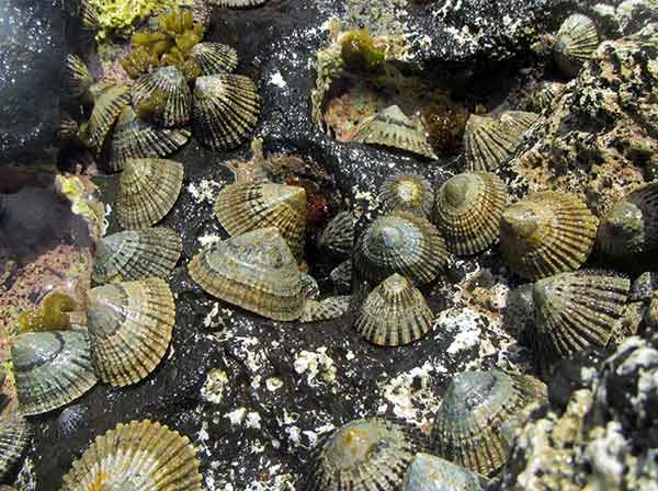 ʻOpihi are abundant along the shoreline of Nihoa in Papahānaumokuākea Marine National Monument. Credit: Hoku Johnson/NOAA |
This ongoing research, led by members of the ‘Opihi Partnership, a public-private collaborative partnership consortium, continues to provide managers with insights into how to make better informed management decisions concerning harvesting of intertidal species in the main Hawaiian Islands. Collaboration is one of the foundational elements of this group, which works to foster and grow public and private partnership efforts to mālama (care for) Hawaii's rocky intertidal shorelines.
The expedition is sponsored by the Office of Hawaiian Affairs, NOAA's Office of National Marine Sanctuaries, Texas A&M University, Nā Maka o Papahānaumokuākea, The University of Hawaiʻi (Hilo and Mānoa), The Nature Conservancy, Conservation International Hawaiʻi, Kipahulu ʻOhana, and Nā Mamo o Mūʻolea.
Co Trustees |
World Heritage |
Big Ocean |
Contact Us Link Disclaimer User Survey Privacy Policy |
PMNM Webmaster Web site owner: National Ocean Service Office of National Marine Sanctuaries National Oceanic and Atmospheric Administration Main Office: NOAA/Daniel K. Inouye Regional Center NOS/ONMS/PMNM, 1845 Wasp Blvd, Building 176 Honolulu, HI 96818 | Phone: 808-725-5800 | Fax: 808-455-3093 |