Diving into History
By guest blogger Melissa Price
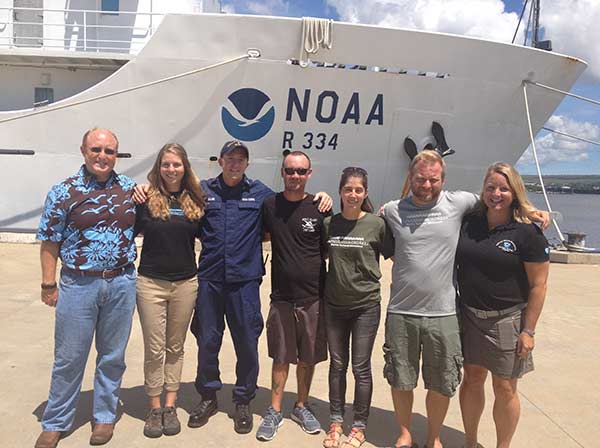 The maritime heritage team that played a part in discovering the Mission San Miguel, from left to right: Andy Collins, Melissa Price, Steve Solari, Ryan Harris, Rebecca Weible, Jason Raupp, and Kelly Keogh. Credit: Toni Parras/NOAA |
Pinch me. That was my first thought when I was asked to participate in the 2015 Reef Assessment and Monitoring Program (RAMP) expedition to the Northwestern Hawaiian Islands (NWHI). I could not quite believe I was invited to join a month-long research venture at sea on board NOAA Ship Hiʻialakai to such a remote place in the world. NOAA personnel were joined by various partners to study and monitor fish, algae, corals and other invertebrates; conduct coral health studies; and explore maritime heritage in Papahānaumokuākea Marine National Monument (PMNM).
PMNM was designated by Presidential Proclamation 8031 on June 15, 2006. At 139,797 square miles, the Monument is the largest fully-protected area in U.S. territory, larger than all other national marine sanctuaries or national parks combined. The NWHI are a chain of islands, atolls and shoals extending approximately 1,240 miles northwest from the main Hawaiian Islands. Since 2000, RAMP expeditions have taken place to collect data on biological and cultural aspects in the Monument.
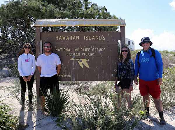 Maritime Heritage field team members (from left to right): Rebecca Weible, Dr. Jason Raupp, Melissa Price, Andy Collins. Credit: Carrie McAfee/NOAA |
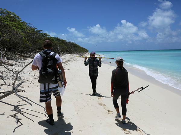 Maritime Heritage field team members survey the beach on Lisianksi Island. Credit: Andy Collins/NOAA |
In late July, I joined Dr. Jason Raupp, PMNM staff member Andy Collins, and University of Hawaiʻi student Rebecca Weible. Together, we constituted the Maritime Heritage Team during the 2015 expedition. Our goals were to investigate and monitor known shipwreck sites, search for reported underwater sites, and conduct terrestrial surveys on select islands. We visited seven sites over a period of thirty days: French Frigate Shoals, Maro Reef, Pearl and Hermes Atoll, Kure Atoll, Midway Atoll, Lisianski Island and Laysan Island.
Based on archival research and historical documents about each area, the team knew the general locations of shipwrecks and shipwreck survivor camps. Searching for sites involved the use of scooters, drift dives and snorkel surveys. After investing great effort, it was satisfying and exciting when we made discoveries. Perhaps the most significant find was a Navy tanker that wrecked in 1957. The team first located the anchors during a visual search in an area near a reef line.
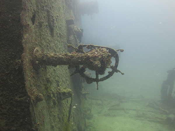 Stern wheel from Navy tanker Mission San Miguel (as it lays on its port side). Credit: Tate Wester/NOAA |
The ship structure, the stern section of which was still complete and lying on its port side, was a few hundred meters away from the anchors and sat in 24 meters of water. It was located through the spectacular efforts of the team, including our amazing small-boat captain, Ryan Harris, a NOAA Corps Ensign on the ship, Steven Solari, and PMNM Maritime Heritage Program Coordinator Kelly Keogh, who prepared the team with all the background and search points for the shipwreck prior to the expedition and provided back up support and research from land during the cruise. We used Coast Guard reports to chart the route of the vessel before it wrecked, providing us with a direction of travel and general location of the wrecking area. The day we located the anchors, we replicated the last reported compass bearing of the tanker and watched the Fathometer for sudden shallow readings. We donned SCUBA gear and jumped in on one particular shallow reading, finding ourselves at the stern section of the tanker. It was an amazing moment: to suddenly turn around and be faced with a giant and eerie vessel that has not been seen for 58 years. The rest of that day was spent exploring the site, taking photographs and basic measurements, and searching for other wreckage in the area. Because the wreck is in a protected Monument with restricted access, we were able to see a virgin wreck, complete with intact portholes and a ship’s wheel.
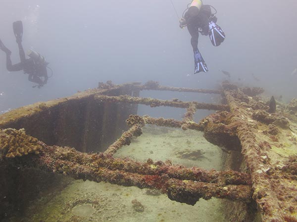 Divers on Navy tanker Mission San Miguel. Credit: Tate Wester/NOAA |
At Midway Atoll, we made another discovery: a WWII-era plane hidden in a groove in the reef. The first thing we spotted was the large three and a half meter propeller. Hull debris and other mechanical parts pocked the area, though some of the debris was camouflaged in the reef. It is possible that this plane crashed during the Battle of Midway in 1942. Researchers are still working to identify it.
Transit between islands provided a chance to catch up on data processing and prepare equipment and plans for the next site. This year, our team was privileged to have the chance to go onshore three islands: Green Island at Kure Atoll, Laysan Island and Lisianski Island. There, we searched for shipwreck survivor camps and remnants of guano farming establishments. Though we did not find much on the islands, it was amazing to see monk seals sunning themselves on the beach and meet researchers who live on the island to study the seals.
Our journey was extended due to the threat of impending hurricanes, causing us to backtrack and evacuate researchers from field camps on three of the islands. We encountered rolling seas, but it was all a part of the experience and our Commanding Officer kept us out of harm’s way. We made it to Pearl Harbor safe and sound and only three days late.
I have been told each visitor to the Monument has his or her own “Ah-ha!” moment. It is hard to pick my favorite moment; every facet of the cruise was new and exciting to me. There was, however, the day three monk seals swam over to our boat to see what we were doing. The curious creatures poked their heads out of the water to watch us and play at the bow before swimming off. We were happy to have the chance to see these endangered animals in their natural environment.
My sincere gratitude goes to Dr. Kelly Keogh, Dr. Jason Raupp and Dr. Jennifer McKinnon for considering me for this year’s expedition. Not only was I able to gain experience in a beautiful and remote area in the Pacific, I was able to encounter life on a ship and build lasting relationships with amazing people. Many thanks also to the other hardworking team members with whom I spent most of my time: Rebecca Weible, Andy Collins and Ryan Harris.
Return to RAMP Expedition Log.
Co Trustees |
World Heritage |
Big Ocean |
Contact Us Link Disclaimer User Survey Privacy Policy |
PMNM Webmaster Web site owner: National Ocean Service Office of National Marine Sanctuaries National Oceanic and Atmospheric Administration Main Office: NOAA/Daniel K. Inouye Regional Center NOS/ONMS/PMNM, 1845 Wasp Blvd, Building 176 Honolulu, HI 96818 | Phone: 808-725-5800 | Fax: 808-455-3093 |