Liberty Ship SS Quartette
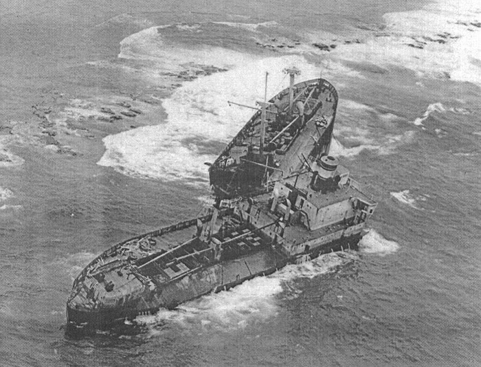
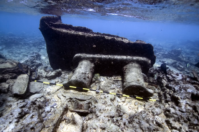
Quartette shipwreck broken apart on the reef. Credit: Bishop Museum
At 7:10 AM on the morning of December 21st, 1952, the 7,198 ton ship SS Quartette struck Pearl and Hermes Atoll on the eastern reef crest while underway at 10.5 knots. Heavy seas and 35-mph winds drove the ship onto the coral, stoving in the bow and heavily damaging two forward holds, but (with the ship firmly aground) the vessel was in no immediate danger of sinking. Navigation fixes (erroneous) had placed the ship some nine to ten miles further away from the reef at the time. The lookout had reported a line of white breakers to the chief mate shortly after 7:00 AM, but allegedly no action to avoid the approaching obstacle was taken. Attempts to back the vessel off from the reef with the engines failed. Soon, though, a navy PBY Catalina flying boat and 170-foot patrol craft (PC 1145) were dispatched from Midway. Thirty-six crewmen were rescued from the ship by the SS Frontenac Victory on the following day, thirty-three of them being taken to Midway Island. The ship's captain and two others (the chief engineer and radio operator) remained standing by on the patrol craft, awaiting the arrival of the Isleway Ltd. salvage tug Ono.
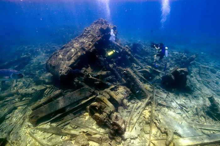
Stephani Gordon films a triple expansion steam engine and wreckage of the SS Quartette. Credit: NOAA/Casserley.
The Ono arrived on December 25th and, putting a towing line on the Quartette, dropped both anchors in an effort to stabilize the stranded vessel. Seas were expected to increase as a storm passed to the northwest, raising concerns that salvage efforts would be postponed. On January 3rd, the tug's anchors parted at the shank, and the Quartette was blown broadside onto the reef. She was deemed unsalvageable, a total loss. Weeks later the ship broke her back (keel) and snapped in two, the bow portion forward of the superstructure finally being pushed into the shallow lagoon, and the stern and midships (engine section) remaining in deeper water to seaward.
The Quartette had originally been launched in Savannah, Georgia as the navy ship USS James Swan in 1944. Named after the Boston Tea-Party patriot, the ship was built for the U.S. Maritime Commission by the Southeastern Ship Building Corporation. By 1952 she had been placed in commercial service. Owned by Standard Steamship Company of Wilmington Delaware, the Quartette was chartered by the Military Sea Transportation Service (MSTS) and en route from Galveston Texas to Pusan, South Korea (via an interim stop at Honolulu) with a load of 9,000 tons of milo yellow grain, consigned to the U.S. Army.
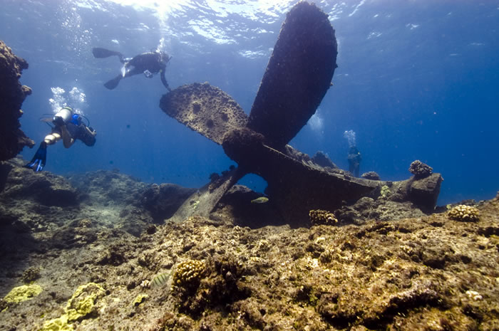
Jason Raupp and Hans Van Tilburg investigate the propeller of the Quartette. Credit: NOAA/Casserley.
The Quartette, an EC2-S-C1 type Liberty ship (official number 246279), was one of the 2,751 Liberty ships which maintained the sometimes tenuous lines of communication and logistical supply overseas during World War II. The Quartette was a three-masted single-screw triple-expansion steam engine vessel, 422-feet long, 57-feet in beam, and with a draft 35 feet deep. Her two water-tube boilers and triple expansion engine were capable of 2,500 horse power. She had three cargo holds forward and two aft. Liberty ships were products of early prefabricated mass production, in large part an industrial response to wartime needs and a definite response to the threat of submarine attacks against merchant vessels. They were relatively simple in design and operation, reducing both construction time and time needed to train engineers. The Liberty ships and their crews of merchant seamen served very bravely during World War II, many facing (and falling victim to) surprise attacks from unseen enemy submarines.
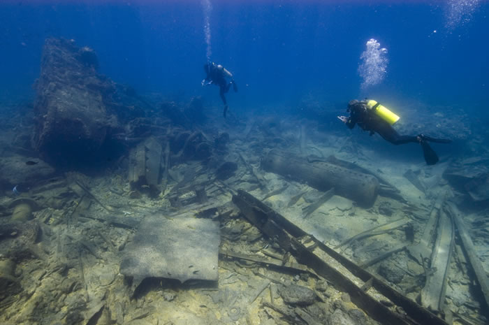
Deirdre O’Regan and Kelly Gleason explore the wreckage of the Quartette. Credit: NOAA/Casserley.
In 2007, a team of NOAA maritime archaeologists initiated a systematic survey of the Quartette's bow section within the reef crest using hand held GPS units to map the site boundary, and a combination of GPS, tape measurements, and digital images to begin locating the major features of the wreck site. These features included forward masts, deck fairleads, superstructure elements, cargo gear and rigging, bridge features, and inner tank and hull structures. Twenty five major features were recorded within an area of over 45,000 square meters. This was a swimming/snorkeling survey in the back reef zone. At times the sea entering the atoll, rolling over the eastern reef crest, appeared to be a river of whitewater, capable of sweeping divers off their feet and "downstream" past the wreckage. The boundary of the wreckage nearer to the crest can only be estimated, as water movement there made all access hazardous. During 2007, the high breaking surf to seaward of the reef crest prohibited all activity at the Quartette's stern's reported 20-foot depth location. Some of the images from previous dives to the ship's components outside the reef (by NOAA National Marine Fisheries Service divers and others) add to the evolving analysis of the entire site.
Bits from the deck of the Quartette inside of the lagoon at Pearl and Hermes Atoll. Credit: NOAA/Casserley.
In 2008, a team of maritime archaeologists returned to the site of the Quartette in order to document the fore reef section of this massive shipwreck. The team discovered that the remains of the ship lie in a huge debris field in close to the exposed reef and are strewn into deeper water. The extent of the wreckage warranted a few days of exploration. Huge elements of this 422 foot long ship are scattered across the reef, including an impressive propeller, steering gear, triple-expansion steam engine, and 4 massive anchors. Photos, video, sketch maps, and GPS data were all gathered and will form the baseline data for the site. In 2010, a small maritime heritage team returned to the site to collect more data and begin work on a site plan.
Links:
US Naval Historical Center
US Naval Historical Center-Underwater Archaeology Branch
National Park Service-Liberty Ships and Victory Ships, America's Lifeline in War
American Merchant Marine at War-Liberty Ships in WWII

A porthole buried in the sand at the Quartette shipwreck site. Credit: NOAA/Casserley
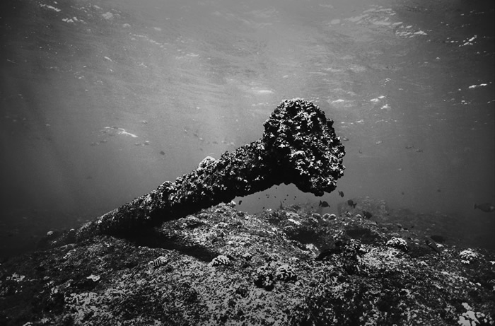
A shaft at the Quartette shipwreck site. Credit: NOAA/Levin.
Co Trustees |
World Heritage |
Big Ocean |
Contact Us Link Disclaimer User Survey Privacy Policy |
PMNM Webmaster Web site owner: National Ocean Service Office of National Marine Sanctuaries National Oceanic and Atmospheric Administration Main Office: NOAA/Daniel K. Inouye Regional Center NOS/ONMS/PMNM, 1845 Wasp Blvd, Building 176 Honolulu, HI 96818 | Phone: 808-725-5800 | Fax: 808-455-3093 |